News
Environmental Threats from Gold Mining in HL Bukit Sanggul
WINDONESIA July 24, 2024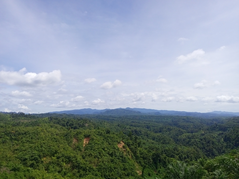 The HL Bukit Sanggul area. (Betahita).
Gold mining activities in the Bukit Sanggul Protected Forest (HL) area, Seluma Regency, Bengkulu Province, are feared to cause various adverse impacts, ranging from the pollution of approximately 2,378 hectares (ha) of local rice fields to natural disasters.
Genesis Foundation conducted a land cover analysis of the Bukit Sanggul Protected Forest area, which spans about 74,152.51 ha, in early March 2024. The land cover was classified into six categories: primary dryland forest, secondary dryland forest, shrubland, dryland agriculture mixed with shrubland, open land, and water bodies.
The results of Genesis' land cover analysis of HL Bukit Sanggul showed that 85.5 percent or 63,426.69 ha is still natural forest, 14.4 percent or 10,668.36 ha have been converted into agricultural land, shrubland, and open land, while 0.1 percent or 57.45 ha are water bodies in the form of rivers.
Currently, HL Bukit Sanggul is designated as part of Energi Swa Dinamika Muda (ESDM)'s Mining Business License (IUP). The mining license, issued by the Seluma Regent under No. I.302.ESDM/2017, covers an area of 30,010 ha. The gold mining license is valid from Aug. 15, 2017, to Mar. 6, 2025, and it includes exploration rights.
Based on Genesis' analysis, 29,414.52 ha, or 98.9 percent of ESDM's concession area in the HL Bukit Sanggul region are natural forest cover, while 317.64 ha, or 1.1 percent, are agricultural land, scrubland, and open land.
Genesis Foundation Research and Forestry Campaign Manager Angga Kurniawan stated that nearly 20,000 ha of the HL Bukit Sanggul area have had their status changed to production forest by the Environment and Forestry Ministry to improve the local investment climate.
A gold mining subsidiary of ESDM has been granted a permit for the revised area. So far, the company has conducted field surveys, topographic mapping, and aerial photography to the concession.
Angga added that a red carpet is laid out for the company to conduct open-pit mining after part of the protected forest area were converted into a production forest. If this open-pit mining is carried out, the path is being laid for increased environmental damage.
"Examples include large-scale deforestation or the loss of vegetation from HL Bukit Sanggul. Trees themselves provide numerous benefits, such as absorbing carbon, producing oxygen, storing rainwater, and much more. Another impact is changes in topography and river water pollution," Angga said on Apr. 1, 2024.
Angga mentioned that rice fields owned by residents in six districts of Seluma, namely Ulu Talo, Talo, Ilir Talo, Talo Kecil, Semidang Alas, and Semidang Alas Maras, that covered a total area of about 2,378 ha will be threatened with crop failure if they use river water contaminated by hazardous substances due to mining activities.
"Because as of now, the rice fields of residents in these six sub-districts still rely heavily on irrigation from the Talo Besar River, Air Alas River, Air Alas Tengah River, and Air Alas Kanan River, [all] which originates from HL Bukit Sanggul, the area included in the revision," Angga said.
Additionally, Angga emphasized that mining activities in Bukit Sanggul could also invite natural disasters. A study by Genesis using altitude and slope data from the Geospatial Information Agency (BIG) found that the area to be downgraded has an elevation of 200-1800 meters above sea level (MASL) with a slope of 25 percent (steep) to 45 percent (very steep). This condition makes the area prone to soil movements and landslides.
Several types of disasters, including floods, landslides, hurricanes, earthquakes, and abrasion have occurred frequently in Seluma Regency according to data Statistics Indonesia (BPS) data on Bengkulu Province from 2020 to 2022.
Of particular concern is that 19 villages have experienced flooding during this period, with 9 of them hit by flash floods. Most of the villages affected by flooding are those located around river streams, such as Air Keruh Village in Ulu Talo District, as well as Lubuk Gio Village, Muara Danau Village, Kembang Sri Village, and Napal Melintang Village in Talo District.
Moreover, Angga stated that a protected forest can be considered damaged if there is a physical change in the forest that prevents it from functioning properly. A damaged forest cannot be utilized to support the livelihood of the local community, and the damage also affects the surrounding environment.
The environment referred to is the unity of space with all objects, power, conditions, and living beings, including humans and their behavior. It is important to know that rivers flow from within the forest.
"So if the forest is well-maintained, the river will also be doing good. But if the forest is damaged, the river will also be damaged," Angga concluded.